
 |
FRANCE GAMBIER Isl. |
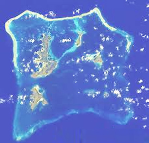
The Gambier Islands (French: Îles Gambier or Archipel des Gambier) are an archipelago in French Polynesia, located at the southeast terminus of the Tuamotu archipelago. They cover an area of 27.8 km2 or 10.7 sq mi, and are made up of the Mangareva Islands, a group of high islands remnants of a caldera along with islets on the surrounding fringing reef, and the uninhabited Temoe atoll, which is located 45 km (28 mi) south-east of the Mangareva Islands. The Gambiers are generally considered a separate island group from Tuamotu both because their culture and language (Mangarevan) are much more closely related to those of the Marquesas Islands, and because, while the Tuamotus comprise several chains of coral atolls, the Mangareva Islands are of volcanic origin with central high islands. Administratively, the Gambier Islands are inside the commune of Gambier, which also includes several atolls in the Tuamotu Archipelago. The town hall (mairie) of the commune of Gambier is located on Mangareva, in the Gambier Islands.

![]()